Short summary
- In Brief: The Catalonia Use Case aims to evaluate Forest DTC in Mediterranean ecosystems, identify potential bottlenecks and determine model calibration needs. We will also assess the suitability of the data produced by Forest DTC for mapping forest fuel and supporting fire risk mitigation efforts.
- Core Users: The Forest Science and Technology Centre of Catalonia, the Consorci Forestal de Catalunya, the Direcció General de Boscos, and the Oficina Tècnica de Prevenció Municipal d’Incendis Forestals i Desenvolupament Agrari.
- Forest type: Mediterranean.
- Study area: Area of interest Catalonia; Prototype demonstration for Central Catalonia.
- Special focus: Evaluating fire fuel hazard modelling and generating fire risk assessments at regional level.
 Validating the Forest Digital Twin's ability to estimate various canopy fuel metrics
 Generating fire risk maps
Fire risk model
Background
- Fire risk model is based on the state and evolution of canopy-related variables that influence the potential for high-intensity fires.
- Variables such as canopy base height, tree height and the apparent density of canopy fuels determine both the probability of crowning (i.e. the ignition of a crown fire) and the capacity of the fire, once the canopies are ignited, to continue burning as a high-intensity crown fire.
Forest DTC implementation
- As currently implemented in the Forest DTC, the fire risk model first calculates the canopy bulk density.
- Combined with the canopy crown base height (a required input), the model then computes the crown fire hazard index.
- The crown fire hazard index ranges from 0 to 1.

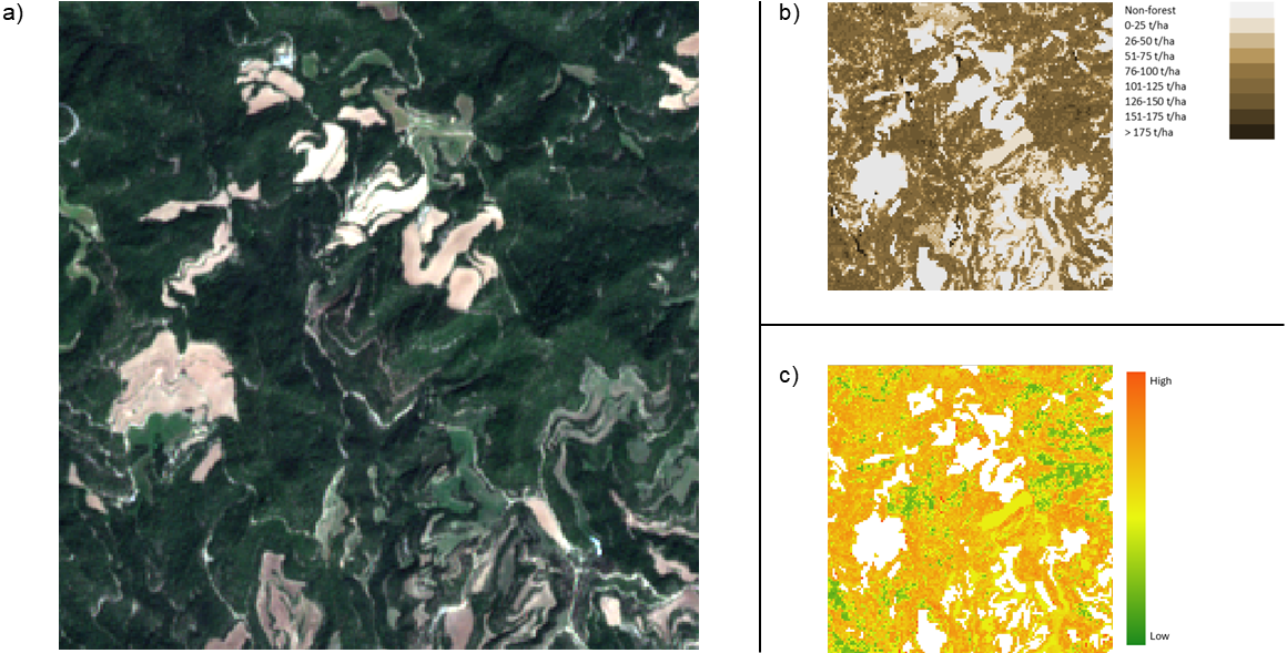
Example outputs of the Use Case
In the figure below, we show an example scene from Central Catalonia. The RGB visualisation of the Sentinel-2 MSI image (a) provides an overview of the forested areas, while the above-ground biomass map represents fire fuel volume (b). The output of the fire risk model is also shown (c).